METHODS
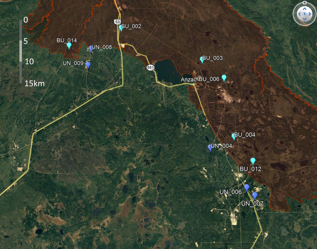
A map taken from Google Earth, showing the sites that were deemed fit for the purposes of our study. The town of Anzac, south of Fort McMurray acts as a distinct reference point within the map. The red polygon shows the extent of the 2016 Fort McMurray fire, with any "BU" points residing within the fire, and all "UN" points falling in the unburned range. Each point represents a pair of sites, for both intact forest and a linear disturbance, each 50m apart.
|
Site selection
When narrowing down site selection, I started by looking at north-eastern Alberta, a location abundant with boreal forest ecosystems, and a robust history of seismic activity. In addition to undisturbed forest vs. seismic lines, sites will be stratified by recently burned vs. mature forest. By selecting sites near Fort McMurray, I can also take advantage of the large McMurray wildlife of 2016, providing a standardized age of fire for all burned treatments. Starting with this large area of possible sites provides ample opportunity to find sites with additional sampling criteria. Ideally, the focus will be placed on sites that are likely to have experienced some level of invasion. Sites adjacent to an already disturbed site - such as a road - are the most likely sites to have invasive species present (Bagi, 1999). To control for the ‘node’ of invasion, all sites should be adjacent to a road, providing a common source of invasion. The objective of this study is to assess how non-native species spread in disturbed areas, rather than simple presence, therefore roadsides showing evidence of non-native species will be targeted. An early assessment of site access and suitability was conducted in May 2018, with 6 burned sites and 5 unburned sites meeting the necessary criteria. With each site then being paired with both intact forest, and a linear disturbance (set 50m apart) I then had a total of 22 unique transects. |
|
Site sampling
Our vegetative measurements will take place in June 2018, while the majority of species are grown and most easily identifiable. When a site is selected using the above criteria, transects will be laid parallel to the seismic line, with a similar line running with the same orientation, 50-100m away, through adjacent forest without seismic activity. The transect will begin at the treeline, and will used as a guide to place 1m² plots at, 1, 2.5, 5, 10, 20, and 40m moving down the line. Sampling is more heavily focused at the beginning of the line as (Honnay, 2002) has shown that the effects of these linear disturbances is greatest within the first few meters. Within each 1m² plot, the percent cover of all species will be estimated. Any unknown species will be collected and pressed to be identified back in the lab. After a full catalog of species has been established, a species database will be consulted to qualify all plants as being native, or non-native to Alberta. |
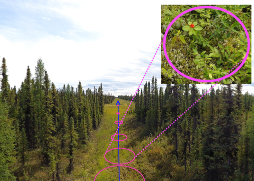
A representation of our sampling design, with a transect parallel to the seismic line, and hoop plots being placed for percent covers of each species to be measured.
|
